Related Links

The National Road in Illinois
When Joseph Shriver and his crew began their Illinois survey in 1828, the state was only ten years old. In his survey journal, Shriver noted the scarcity of homes and even had an encounter with Indians. The path of the road brought it to Vandalia, our state capital from 1819 until 1839. The street in front of the capitol, Gallatin, was named in honor of the man who supported construction of the National Road.
William C. Greenup served as Illinois construction superintendent and was faced with the monumental challenge of finding laborers. He was also responsible for paying the workers with gold which, according to folklore, he kept under his bed until payday. A town Greenup co-founded in Cumberland County bears his name.
With the exception of the occasional crushed rock or timber-laden "corduroy" sections, the Illinois National Road was a dirt path dotted with tree stumps cut low enough that a wagon could easily navigate over them. The "Gazetteer of Illinois", published in 1837, described the National Road as "80 feet wide, the central part, 30 feet wide, raised above standing water, and not to exceed 3 degrees from a level." Englishman William Oliver wrote of his 1843 travels in Illinois which included the National Road east of Vandalia. He observed, "laborers forming the road on the prairie; this was done by merely excavating the earth from each side, and throwing it into the middle."
A heavy rain would transform the National Road to a muddy trail, sometimes forcing travelers to find an alternative path. For instance, Altamont, Illinois historians believe there were 3 areas that were known as the National Road. People came to Illinois on the National Road in wagons, stagecoaches, horseback, or on foot. Sometimes they would stop at an inn for a hot meal and to visit with other travelers. Beds were at a premium so it wasn’t unusual to sleep on the floor.
Although federal funding was discontinued before the road was completed in Illinois (construction stopped at Vandalia), the National Road impacted the young state of Illinois. The census showed a population of 157,445. Ten years later the numbers had soared to 476,183. State officials urged the federal government to continue road construction; however, the two sides differed on the route. Illinois wanted the National Road to go to the Mississippi River at Alton while the feds preferred a trail to St. Louis. The argument was never settled as funding was not restored.
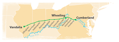
Today the Illinois National Road stretches 164 miles from the Indiana border to the Mississippi River in East St. Louis and encompasses seven counties---Clark, Cumberland, Effingham, Fayette, Bond, Madison, and St. Clair. The National Road Association of Illinois recognizes the National Road to St. Louis as surveyed by Shriver and intended by the federal government. Many of the communities owe its origin to the National Road bringing the settlers that turned prairieland to civilization.